HASSIA Landgraviatus, Wilhelm Dilich, 1662

HASSIA Landgraviatus, Wilhelm Dilich, 1662

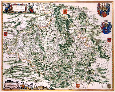
The first maps of hessen appeared in sebastian münsters cosmographia (1550) and abraham ortelius (1527-1598) theatrum orbis terrarum (1575). These maps were based on the work by j. Dryander. 17th-century maps were mainly based on the topographical survey of hessen carried out between 1607-1617 by wilhelm dilich (1571-1655) ordered by the landgrave moritz van hessen. The survey resulted in 27 maps. This version of the map was probable published by joan blaeu (1598-1673). Object Type: map. Date: 1662. Place of creation: Amsterdam. Dimensions: 45 x 55 cm. Medium: copper engraving print. Collection: Koninklijke Bibliotheek. Atlas Van der Hagen-KW1049B10 089-HASSIA Landgraviatus
Edit image
Published by:
Creazilla
Author: Dirk Jansz van Santen (1636–1708)Source: commons.wikimedia.org

Loading...

0 downloads
Loading...
atlas van der hagenatlas van der hagen (volume 1)old maps of hessemaps of hesse-casselworks by wilhelm dilichcopper engraving printkoninklijke bibliotheekwilhelm dilich

MORE LIKE THIS

Creazilla logo
Over 10 million free graphic resources for content creators and designers.
© 2018 - 2025 Creazilla
Our resourcesAll imagesPhotosDigital illustrationsClipartIconsPNG ImagesEmojisSilhouettesTraditional Art3D ModelsVectorsFontsColor namesColor palettesGradientsAudioAnimationVideosTemplates
InformationAbout CreazillaTerms of useTech teamPrivacy policyLicence Information
FeedbackContact Us