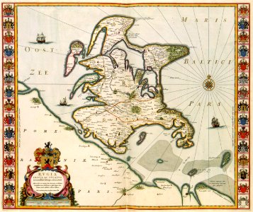
At the time willem jansz. Blaeu (1571-1638) first published his map of the baltic island of rügen in 1631 it formed part of pommern; when this reissue appeared thirty years later it had become part of sweden. For this map, blaeu used information of the wall map of pommern by eilhard lubin (1565-1621). The coats of arms are those of the islands leading families. Object Type: map. Date: 1631. Place of creation: Amsterdam. Dimensions: 45 × 55 cm. Medium: copper engraving print. Collection: Koninklijke Bibliotheek.
Loading...